
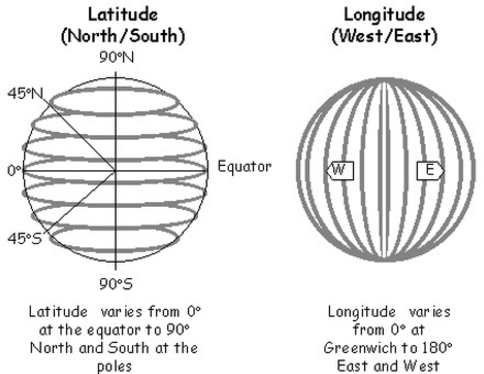
To determine position on the open seas, one need to measure the Latitude (north and south) and Longitude (degrees east and west).
From Wikipedia (https://en.wikipedia.org/wiki/Geographic_coordinate_system)
To determine distances position north and south, one needs three things: a tool to measure the angle between the horizon and the max altitude of the sun, the date, and charts with the latitude as a function of the sun’s maximum altitude.
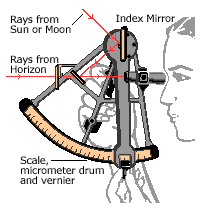
The measurement tool can be as simple as an outstretched hand or as complicated as a sextant. From Wikipedia (https://en.wikipedia.org/wiki/Celestial_navigation): Accurate angle measurement evolved over the years. One simple method is to hold the hand above the horizon with your arm stretched out. The width of the little finger is an angle just over 1.5 degrees elevation at extended arms length and can be used to estimate the elevation of the sun from the horizon plane and therefore estimate the time till sunset.
The need for more accurate measurements led to the development of a number of increasingly accurate instruments, including the kamal, astrolabe, octant and sextant. The sextant and octant are most accurate because they measure angles from the horizon, eliminating errors caused by the placement of an instrument’s pointers, and because their dual mirror system cancels relative motions of the instrument, showing a steady view of the object and horizon.
 From http://blogs.southcoasttoday.com/numbers/2015/03/02/where-are-we-look-at-the-stars/
The date can just be an accepted calendar.
The charts (using the same calendar) must be generated by hand using pre-determined latitude positions. For example, using Reykjavik (Iceland) which is located at 64 degrees North, one can generate the following data (by taking measurements throughout the year):
| Latitude (degrees) | date | Max Sun Altitude |
|---|---|---|
| 64 | January 1st | 3.2 |
| 64 | February 1st | 9.92 |
| 64 | March 1st | 18.8 |
| 64 | April 1st | 30.9 |
| 64 | May 1st | 41.3 |
| 64 | June 1st | 48.2 |
| 64 | July 1st | 49.1 |
| 64 | August 1st | 43.8 |
| 64 | September 1st | 34.0 |
| 64 | October 1st | 22.6 |
| 64 | November 1st | 11.4 |
| 64 | December 1st | 4.3 |
To complete the chart, one needs more dates (which I have avoided here for simplicity) and the angles at different Latitudes (here I just added three, again for simplicity) to obtain:
| Date | Max Sun Altitude at Latitude = 44 degrees | Max Sun Altitude at Latitude = 54 degrees | Max Sun Altitude at Latitude = 64 degrees |
|---|---|---|---|
| January 1st | 23.9 | 13.1 | 3.2 |
| February 1st | 28.9 | 18.9 | 8.9 |
| March 1st | 38.8 | 28.8 | 18.8 |
| April 1st | 50.9 | 40.9 | 30.9 |
| May 1st | 61.3 | 51.3 | 41.3 |
| June 1st | 68.2 | 58.2 | 48.2 |
| July 1st | 69.0 | 59.1 | 49.1 |
| August 1st | 63.8 | 53.8 | 43.8 |
| September 1st | 54.0 | 44.0 | 34.0 |
| October 1st | 42.5 | 13.1 | 3.2 |
| November 1st | 31.3 | 21.4 | 11.4 |
| December 1st | 24.1 | 14.1 | 4.3 |
Obviously, more intermediate dates and latitudes are necessary. These would fill a very large atlas (think of the number of data points for 365 days and 180 degrees!).
The above date collected from this Navy site: http://aa.usno.navy.mil/data/docs/AltAz.php
So, if you are sailing in a Viking ship (as my characters do in my second book which will be published in late 2016), you need to monitor the altitude of the sun above the horizon. Take several readings during the noon hours, chose the largest value and check that value in your atlas. If the maximum value is 49 degrees and the date is August 15th, the latitude is approximately 58.8 degrees from the above table. If you are sailing to Reykjavik, you better turn North a bit as the latitude of Reykjavik is 64 degrees.
How far east and west are you? I’ll cover longitude in my next post.