To determine position on the open seas, one need to measure the Latitude (north and south) and Longitude (degrees east and west). But longitude is a more difficult task.
Quick review:
- Latitude: how far north or south, referenced to the equator (halfway between the north and south poles).
- Longitude: how far east or west from some agreed upon position (now-a-days pinned to the Royal Observatory in Greenwich, England).
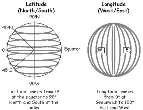
Latitude and Longitude from Wikipedia
From Wikipedia (https://en.wikipedia.org/wiki/Geographic_coordinate_system)
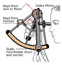
While it is possible to determine the longitude by observing the stars (or even the moons of Jupiter), these measurement require a degree of accuracy impossible on the rolling deck of a ship at sea.
A solution to this problem is the use of accurate timepieces.
- …Two observers note the time when the sun reaches its highest point in the sky
- …The difference in time is directly related to the angle between the two observers on the surface of the earth
- …24 hours = 360 degrees
- …Each hour of difference = 15 degrees
- …The angle between the position of the two observers can be use to determine distance
- …Each degree = (circumference of the earth)/(360 degrees) = 69.2 miles where the circumference = 24900 miles.
- …Using Nautical miles, each degree = (21639 nautical miles)/(360 degrees) = 60 nautical miles
- …So that each minute of angle (60 minutes to a degree) = 1 nautical mile
- …So for each hour of difference between the two observers, they are 60 nautical miles apart (or 69.2 land miles).
- Easy. Right? Well, it’s only easy if the two observers are using clocks that have been synchronized and keep accurate time.
Today, any pair of inexpensive wristwatches would suffice. However, not until the eighteenth century, could such accurate clocks be constructed.
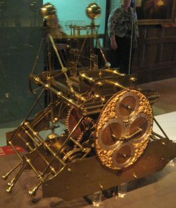
John Harrison’s first chronometer
Prior to the 18th Century, navigators could determine latitude (distance north or south) but could only guess their east-west position by dead reckoning (estimating the speed of their ship, estimate of the direction of travel, and estimating their time duration). Hence the name “dead” reckoning.
In my time-travel, alternative history novels, common wristwatches become a highly valued navigational aid. (In your story, make sure they run on internal springs and not batteries!).
The tale of John Harrison’s construction of an accurate chronometer in the 18th Century is well told in “Longitude” by Dava Sobel.